
story
Jemez Falls: The Waterfall, Trail and Access Questions
Jemez Falls brings together pine forest, rocky terrain and a waterfall on the East Fork of the Jemez River.
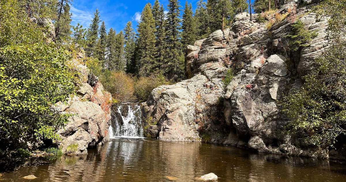
Jemez Falls brings together pine forest, rocky terrain and a waterfall on the East Fork of the Jemez River. It belongs on a New Mexico itinerary as a forest walk and waterfall viewpoint, with enough time to enjoy the setting. The falls and nearby warm springs are separate destinations; a visit to the waterfall should not be planned as a hot-spring soak.
As of September 6, 2026, Recreation.gov is actively listing Jemez Falls Campground and describes Jemez Falls as a half-mile hike from the campground. The current listing also notes a Cerro Pelado Area closure affecting Trail 137 south of the East Fork Trailhead, while entry is allowed north from East Fork Trailhead to Las Conchas Trailhead.
Check current forest conditions before driving
The current Jemez Falls Campground listing is the most useful planning reference I found for the recreation area. It lists campsites and identifies Jemez Falls as a nearby half-mile hike. That is a stronger current signal than the July fire notice that temporarily closed the campground and trailhead.
There is also a separate Forest Service closure for Jemez Cave through April 30, 2027. That order applies to Jemez Cave, not Jemez Falls. Because forest, fire and road conditions can still change, check Santa Fe National Forest alerts and the current Recreation.gov page before setting out.
If a new closure is posted, respect it rather than improvising an approach from a neighboring trail or following an older map around a gate. A closure can involve hazards that are not obvious from the first few steps into the forest.
Know which outing you are planning
Recreation.gov’s Jemez Falls Campground page places the campground at about 7,880 feet and identifies Jemez Falls as the largest waterfall in the Jemez Mountains, reached by a half-mile hike from the campground. The campground listing includes paved access, vault toilets and drinking-water spigots during the operating season. Current notices on that page should be checked alongside Forest Service alerts before a visit.
The distinction between destinations matters when estimating effort. A walk toward the falls, a longer route through the trail system and an outing to warm springs are not interchangeable simply because they share an access area. Pick a specific route and confirm that route is open before deciding what to carry or how much time to leave.
The accessible picnic facilities also should not be read as a claim that every trail beyond them is accessible. If someone in the group needs a particular surface, grade or facility, ask the district for details. It is better to settle that question in advance than to make assumptions from the picnic listing.
Build a forest day around a realistic route
When the site is open, save the current route information and directions before leaving reliable service. Recreation.gov describes the approach from Jemez Springs along State Road 4 and Forest Road 133 South. Use that as a location reference alongside current road guidance, not a reason to proceed past a closure.
Give the outing a start time, a turnaround time and a clear endpoint. That can be as simple as agreeing to walk to the permitted viewpoint, pause there and return for lunch. Adding another destination should be a deliberate decision made with the route, daylight and group’s energy in mind.
At this elevation, pack for a forest outing rather than whatever the weather felt like at your starting point. Bring water, a layer and footwear suited to walking. Keep the bag manageable and allow time for breaks. A short distance on a map still deserves enough preparation that a change in conditions does not immediately spoil the day.
Keep waterfall viewing separate from water entry
The useful expectation here is a waterfall walk and view. Nothing in the official picnic description establishes a designated hot pool at the base of Jemez Falls, and the nearby warm-spring references should not be used to imply one. Follow signs and stay on the permitted route.
For general context, the National Park Service’s river guidance cautions that moving water can hide currents and slippery surfaces. A place that looks inviting in a photograph is not evidence that getting closer to the edge or stepping into the channel is appropriate.
For photographs, work from stable, permitted ground and leave room for other visitors to pass. If the angle requires leaving the route, choose another composition. The landscape remains the subject without needing a person perched near a drop.
Keep the wider itinerary flexible
The Jemez Mountains offer more than one reason to stop, but combining destinations requires checking each one separately. The picnic-area listing mentions Valles Caldera and Bandelier among regional attractions. They have their own access information, travel times and visitor requirements, so treat them as separate planning decisions rather than guaranteed additions to the same day.
A good waterfall itinerary leaves space for the actual conditions. That is also true of Cleo’s Bath near Pinecrest, where the approach matters as much as the destination. For Jemez Falls, the first useful step remains a current access check; the rest of the day can follow once that answer is clear.
All About The Life
Make A Story Worth Telling
A scenic vintage-inspired design that encourages you to “Make A Story Worth Telling.” Mountains, water, sunset, and tropical details give it an adventurous feel that’s perfect for travelers, explorers, and anyone who wants a life filled with moments worth remembering.